
El La Paloma Puddle o Charco de Las Palomas is located in the municipality of Tejeda, in the interior of Gran Canaria. Specific, It is about 15 minutes walk from the giant basket that we find on the road that connects the town of Tejeda with Roque Bentayga. In the following lines we are going to talk to you about how to get to Charco de La Paloma, as well as We are going to propose a hiking route to get to know this area of Tejeda on foot. Don't miss the video at the end!

El Charco de La Paloma
This natural resource is characterized by its large waterfall and pond. Furthermore, as its name suggests, you can see some pigeons swarming along the tops of the waterfall. When it has rained a lot, you can see how The waterfall has a large flow that in turn runs through the Tejeda ravine. Without a doubt, it is a good plan to combine with a visit to the town of Tejeda, Roque Bentayga or with a hiking route like we did.

Keep in mind that the photos and video we show you are from February 2021, after several weeks of rain in Gran Canaria. Therefore, the landscape can vary in the drier months.
How to get to Charco de La Paloma
To get to Charco de La Paloma You can park next to El Cesto de Tejeda or even in the town of Tejeda itself and walk VERY carefully on the road. Next you must descend through the ravine towards the interior of the mountain. You just have to walk for about 10 minutes and cross the flow of the stream and you will see it. If you can follow a map better, since it is not marked and it is easy to get lost. us anyway We are going to share with you the complete track that passes through Charco de La Paloma and other places of interest below.

Circular Hiking Charco de La Paloma – Cruz de Timagada
As we mentioned, we We did a hiking route through Charco de La Paloma what was going on more places of interest. In this way, we took the opportunity to get to know this part of Tejeda. In principle, as we see it, it is about a fairly easy route without major dangers of slipping or falling.
El accumulated difference is about 480 meters, so we could say that It is suitable for anyone who can last 3 hours walking. Even so, We always recommend that you be well prepared with appropriate footwear, food and water. Add to this a good coat if they are cool months. Likewise, we recommend that before going you check the weather forecast and prepare your hiking kit.
| Approximate distance | 7,7m |
| Approximate duration on foot | 3 hours |
| Level | Initiation-intermediate |
| Total promotion | 480m |
| Circular | Yes |
| Picnic zone | No |
✔ La Culata de Tejeda
It is a circular route that passes through the town of La The Butt. Here you can stop to have a drink or even eat if it coincides with midday. This way, you can divide the section into two, either if you are going with children or with people who have to take more breaks due to their physical condition.


✔ Timagada Cross Viewpoint
This hiking route that starts from Charco de La Paloma also passes through a very special and little-known place. This is the viewpoint of La Cruz de Timagada, within the Nublo Rural Park. Is located at 1.285 m altitude, so you can imagine the views from here to Tejeda and the Roque Nublo.


✔ Roque Nublo and Bentayga
We also leave you with some photos taken from the trail to Natural Monument of Roque Nublo. As you can see in the video at the end, if you decide to do this route, you will also meet the Roque Bentayga.

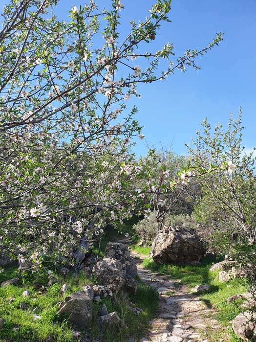
At the same time, if you go in the months of January, February and/or March, you will probably be lucky enough to see numerous Almond trees in bloom y streams or small waterfalls like it happened to us. In any case, the route is beautiful and worth doing.

Of course, as we said, If you want to see the almond tree in bloom, try to go in the months of January, February and March.

✔ Track of the Charco de La Paloma – Cruz de Timagada route
Here you will be able to download the track of this route hiking through Gran Canaria and what we show you in the following video. If you want to know how to download the map in .gpx format to follow it on your own from your GPS-watch or smartphone, here we explain it to you. If you want to support us so that we continue creating content for you about Gran Canaria, we would appreciate it if you purchased any of our tracks, either to enjoy incredible routes or as a donation. Oh, and don't miss the video we have prepared for you below!

Video of the hiking route
Finally, also We have prepared a short video of this walking route for you to encourage you to discover the most authentic side of Gran Canaria on your own.. If you want to see more videos of plans to do on the island like this one, you can subscribe to our YouTube channel here.
Gran Canaria Guides
Do you want to know more plans like this? Take a look at our most read articles below:
If you don't feel like surfing and surfing the internet, in our digital guides to Gran Canaria you can become an expert on the island without wasting your valuable time. You can see them all below.


We are Ruth & Jorge, Gran Canarian people with a traveling soul. Experts in tourism and digital marketing. We share the most authentic side of Gran Canaria (where we live) and… our adventures around the world!

Hello, this route is suitable for pets, I know it is a job but an area on the pet-friendly website would be cool.
Hello Ruben! Yes, as you can see in the video, we went with our dogs! We take note of the pet friendly suggestion 🙂 A hug
Third thing we do about you, and we loved it, spectacular day, the dry puddle not the next thing hehehe... we expected it at the time... on to the next one... thank you.
Hi David!! How good to read you again! This route is brutal, it is better to repeat it after the rains and when the almond tree is in bloom, but it is still beautiful.
A hug and continue with the next one 🙂
Hello good morning. I saw your page and the comments about Charco de la Paloma.
Can you tell me how far it is to walk from a point where you can get to the waterfall by car?
Many. thank you!
Hello Conny!! Right now there is no waterfall because it hasn't rained in months. It takes about 10-15 minutes to get to the place where the waterfall forms, depending on each person's pace.
A hug