
On this occasion we want to share with you a hiking route through the municipality of Valsequillo: the Tajinaste Azul route. This is a circular route that runs along two of the trails where you can see the largest populations of this endemic species of Gran Canaria. Shall we go hiking in Gran Canaria? Join us!

The Blue Tajinaste or Tajinaste of Tenteniguada
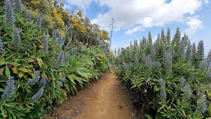
El Blue tajinaste or Tenteniguada tajinaste It is a shrub that has blue flowers with an elongated shape. Tajinaste flowers too They can be white or pink or a combination of all 3 colors.. This type of tajinaste is exclusive to Gran Canaria, in other words, does not exist in other parts of the world. And You can find its largest sample in the Tenteniguada area, in the municipality of Valsequillo. However, it is also present, although to a lesser extent, in other areas of the north and northwest of the island of Gran Canaria. For example, in the municipalities of San Mateo, Firgas, Teror and Valleseco.

Tajinaste Azul Route, hiking in Valsequillo
To see the Tajinaste Azul in its splendor, we recommend doing this hiking route through Valsequillo in the months between February and April. During these months is when we will see the tajinaste in flower. Also, if you go in February or early March, there will probably be some left. Almond Blossom, also known in this municipality of Gran Canaria. In any case, the start date of flowering will depend on the weather in the previous months.

These trails are of great scenic and scientific interest, since they mostly run along the Los Marteles Special Nature Reserve. Additionally, during the walk we will have views of Roque Grande, Roque Saucillo and practically the entire Valsequillo valley. If the day is clear you can even see the city of Las Palmas de Gran Canaria. We will also go through the Cuevas Blancas dam and we will approach a hidden point to have a unique panoramic view of the Caldera de Los Marteles.

Keep in mind that once in the Caldera de Los Marteles, in addition to doing more fresh, the vegetation changes and we will be surrounded by canary pine forest. Anyway, Both the ascent and the descent, we will spend 90% of the route among blue tajinastes.
Route characteristics
The first part of the route is all ascending, then we will walk a part on the flat to end up descending again to Tenteniguada. We leave from the valsequillero neighborhood of El Rincón, since this day we wanted to end up eating in Valsequillo (we show you in the video). However, you can exit perfectly from The Caldera de Los Marteles If it suits you better. There are a few more parking spaces here than in El Rincón. In addition, there is usually a kiosk-type van where you can buy water and food.
| Distance | 8,7 km |
| Approximate duration | 3 hour and 50 |
| Total promotion | 772m |
| Level | Intermediate |
| Circular | Yes |
| Picnic zone | No |
Please note that the route is recommended for people with good physical shape, since it has quite a slope. Are about 800 meters of positive slope and almost 4 hours long. As we always recommend, carry the basic hiking kit with you to avoid discomfort, possible accidents, dehydration, heatstroke, etc.
Track of the Tajinaste Azul route
Now, You can download the track of the circular route in .gpx format so you can follow it on your own without getting lost. If you don't know how to download it and follow it from your GPS-watch or smartphone with the Guru Maps app, here we explain it to you. The condition of the trail will depend a lot on the rains, please don't risk it if you see danger. If you want to support us so that we continue creating content for you about Gran Canaria, we would appreciate it if you purchased any of our tracks, either to enjoy incredible routes or as a donation. Oh, and don't miss the video we have prepared for you below!

We left the car in a small parking lot. The Corner of Tenteniguada. A few steps away is the beginning of the trail. Anyway, as we told you before, you can also start from the Caldera de Los Marteles. It depends on what works best for you and what you feel like doing next. Here we tell you more things what to do in Valsequillo.
Where to eat in Valsequillo
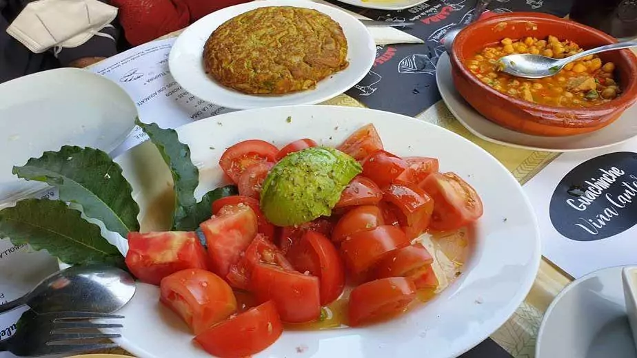
When we record this route We went to eat at Guachinche Viña Cantera. A place that we recommend to eat good, nice and cheap in Valsequillo. We show it to you and explain everything at the end of the video! If you want to know more options restaurants in Valsequillo, take a look at that article on our blog.
Video of the route
Below we leave you with the video of the route, subscribe to our YouTube channel to find out when we have new videos about plans to do in Gran Canaria!
Tajinaste rural house
Without a doubt this area of the island is a good area where to stay in Gran Canaria. We recommend the Tajinaste Country House. An ideal corner in Valsequillo to disconnect from everyday life and connect with nature.

Gran Canaria digital guides
If you want to know more routes hiking in Gran Canaria We invite you to browse a little through our hiking section. Likewise, if you would like to discover the most authentic side of the island of Gran Canaria and save time when planning your trip, you cannot miss our digital guides to the island. You have them all just one click away!


We are Ruth & Jorge, Gran Canarian people with a traveling soul. Experts in tourism and digital marketing. We share the most authentic side of Gran Canaria (where we live) and… our adventures around the world!

That beauty!
This magnificent report will help Gran Canarians, Canarians and visitors learn about the scenic beauty and biodiversity (and gastronomy) of the municipality of Valsequillo.
THANK YOU SO MUCH
Hello José Antonio! Thank you very much for your comment, a hug!!
Hello Rosa Delia! That's great, we love reading comments like this 🙂 We invite you to subscribe to our weekly newsletter where we share new routes, plans to do and places to eat: https://localguidegrancanaria.com/newsletter/